Abstract
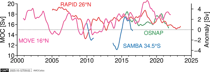
One Python API for loading and comparing AMOC transport datasets — from moored observing arrays to satellite/Argo-based estimates — with consistent variable names, units, and metadata. AMOCatlas provides unified access to data on the Atlantic Meridional Overturning Circulation (AMOC), spanning both in-situ observing arrays (RAPID, OSNAP, MOVE, SAMBA, …) and blended or estimation-based products (satellite altimetry, Argo, and reanalysis-derived estimates). Instead of hand-parsing a different file format for each source, you load any of 18 datasets through one interface and get back standardised, analysis-ready xarray datasets. AMOCatlas does not alter the underlying data; it re-serves the same values as the source publications, adding standardised units, variable names, attribution, and provenance metadata.

Eleanor Frajka-Williams
Professor of Ocean Dynamics in a Changing Climate
I am a physical oceanographer who uses ocean observations to investigate ocean dynamics and circulation in a changing climate. I have a particular interest in problems spanning scales (from micro- to large-scale) or spheres (biogeosphere, cryosphere, atmosphere), and in methods that leverage traditional observations with new platforms and satellite data.
